


CASE STUDY
Uganda Case Study
Scope of Work
Overview
- Located in north-eastern Uganda, the Uganda Graphite Project focuses on developing a significant deposit of jumbo-flake graphite. Originally identified in the 1960s, the site has undergone extensive modern exploration since 2014, including aerial surveys, trenching, and multiple drilling phases. The local geology is defined by metamorphosed carbonaceous shales within the West Karamoja Group, which was shaped by ancient tectonic activity.
- Managed by Minrom, the project aims to establish a JORC-compliant resource to support commercial mining operations. Recent metallurgical tests indicate that the site offers high-quality mineral flakes suitable for easy extraction. The development marks a transition from historical geological surveys to a structured resource declaration for international investment.
Commodity
Graphite (C)
Country
Uganda
Project Type
Non-invasive Exploration

The Uganda Graphite Project is a jumbo-flake graphite project located in north-eastern Uganda which has undergone several phases of exploration since its inception in 2014. A prominent mountain range dominates the project area which was historically explored for copper (Cu) and Zinc (Zn) in the 1960s by Mr. Morton, an English geologist. This is when the first occurrences of graphite were discovered but the potential was never fully explored. Minrom performed a mapping programme within the project area in 2014 and the project has since seen further exploration phases including aerial geophysical surveying, trenching and scout exploration drilling. A change of project ownership in 2019/2020 kickstarted additional exploration drilling performed by Minrom, which is currently underway in declaring a JORC compliant resource.
The geology of the project area is dominated by the Neoproterozoic West Karamoja Group rocks. This group consists predominantly of basic granulites, garnet-bearing granulites and graphitic granulites. The Neoarchean Amuru Group consisting of gneisses and amphibolites underlies the West Karamoja Group. The Neoproterozoic West Karamoja Group was over thrusted onto the Neoarhean Amuru Group during the Pan-African Orogeny, creating the allochthonous klippe structures. Intrusive bodies are scattered throughout the area. The graphite mineralisation is understood to be a product of the metamorphism of former carbonaceous shales.
Regional Geology
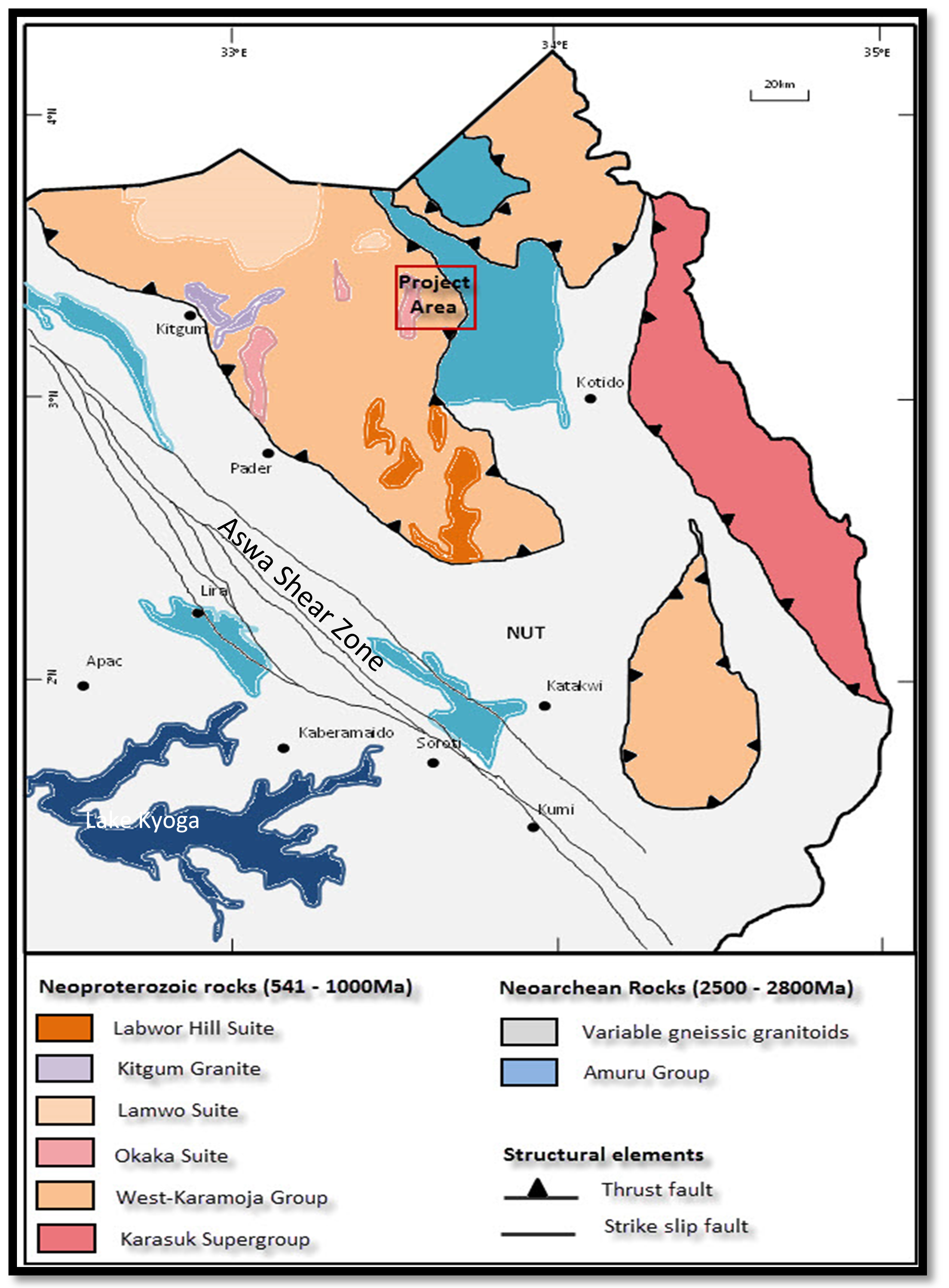
Minrom performed a Phase 1 surface mapping and sampling programme in July 2015 across the exploration license, with the aim of mapping the graphite-bearing units and describing the local lithologies in full detail.
Figure 1
Regional geology of the project area
The Uganda Graphite Project is a jumbo-flake graphite project located in north-eastern Uganda which has undergone several phases of exploration since its inception in 2014. A prominent mountain range dominates the project area which was historically explored for copper (Cu) and Zinc (Zn) in the 1960s by Mr. Morton, an English geologist. This is when the first occurrences of graphite were discovered but the potential was never fully explored. Minrom performed a mapping programme within the project area in 2014 and the project has since seen further exploration phases including aerial geophysical surveying, trenching and scout exploration drilling. A change of project ownership in 2019/2020 kickstarted additional exploration drilling performed by Minrom, which is currently underway in declaring a JORC compliant resource.
The geology of the project area is dominated by the Neoproterozoic West Karamoja Group rocks. This group consists predominantly of basic granulites, garnet-bearing granulites and graphitic granulites. The Neoarchean Amuru Group consisting of gneisses and amphibolites underlies the West Karamoja Group. The Neoproterozoic West Karamoja Group was over thrusted onto the Neoarhean Amuru Group during the Pan-African Orogeny, creating the allochthonous klippe structures. Intrusive bodies are scattered throughout the area. The graphite mineralisation is understood to be a product of the metamorphism of former carbonaceous shales.
Regional Geology
Figure 1
Regional geology of the project area
Minrom performed a Phase 1 surface mapping and sampling programme in July 2015 across the exploration license, with the aim of mapping the graphite-bearing units and describing the local lithologies in full detail.
Photographic Data
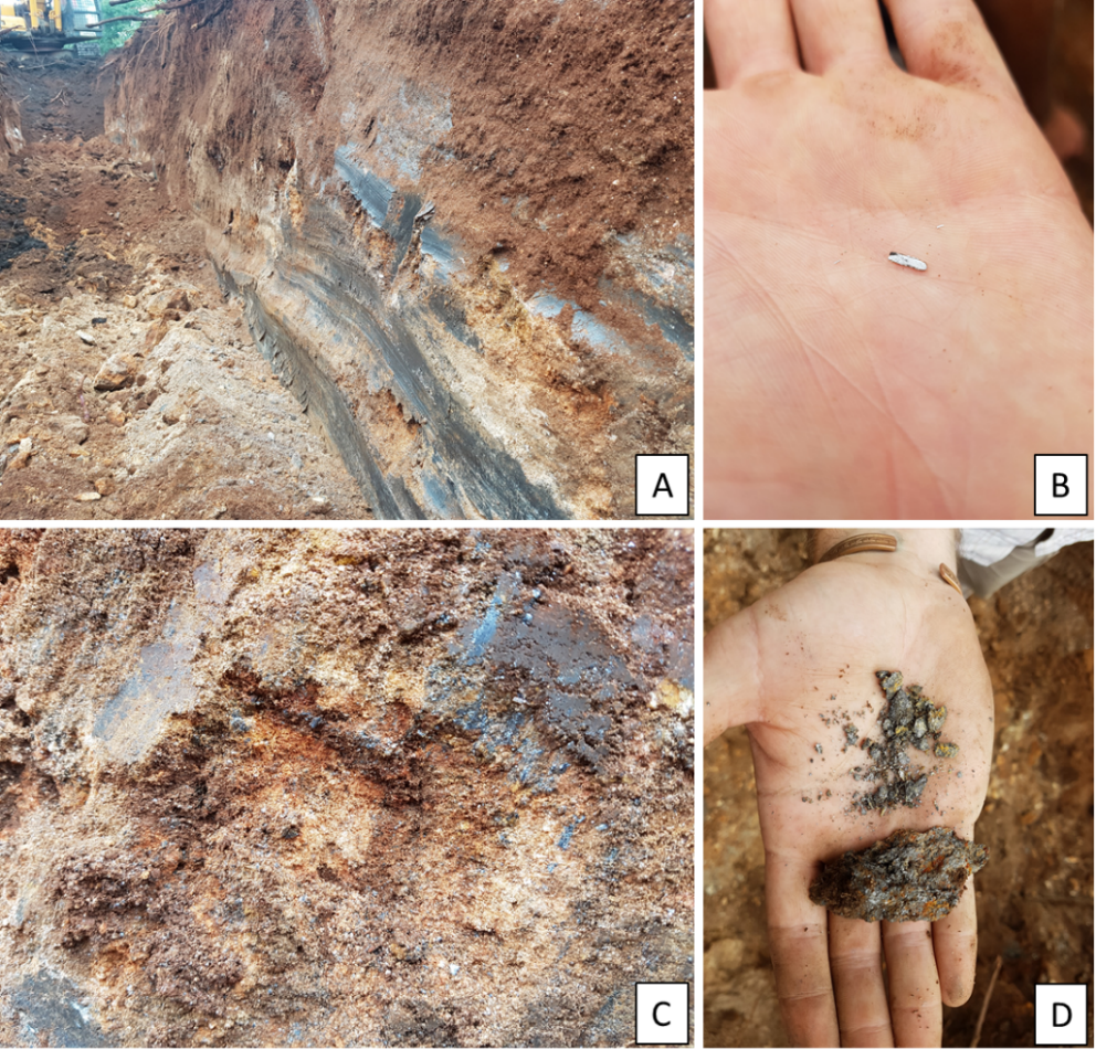
Figure 2
Phase 1 mapping of the graphite-bearing units
The results of the mapping were so promising that an initial 600 m of diamond drilling and sampling was initiated in August 2015, with the primary aim of determining the in-situ graphitic carbon grades and associated mineral occurrences.
As the full extent of the deposit was still not fully understood, due to the thick vegetation cover in the project area, an electro-magnetic geophysical survey was performed in May of 2016 by Geotech – VTEM. The survey totalled 1078 km of geophysical lines and resulted in numerous large well-developed geophysical anomalies identified across the licence area. These anomalies were systematically investigated in a follow-up Phase 4 trenching programme.
Minrom is currently managing the 5th phase of exploration on the project This phase includes the set-up of an exploration camp, drilling of a water borehole and a total of 1800 m of exploration diamond core drilling, logging, and sampling. Minrom is excited for the outcome of this project. Metallurgical test work and optical microscope work revealed that the graphite deposit can be characterised as a jumbo and large flake deposit that will be mostly free dig operations. Minrom will declare and report a JORC resource on the project in August 2020 for the London listed entity.
Photographic Data
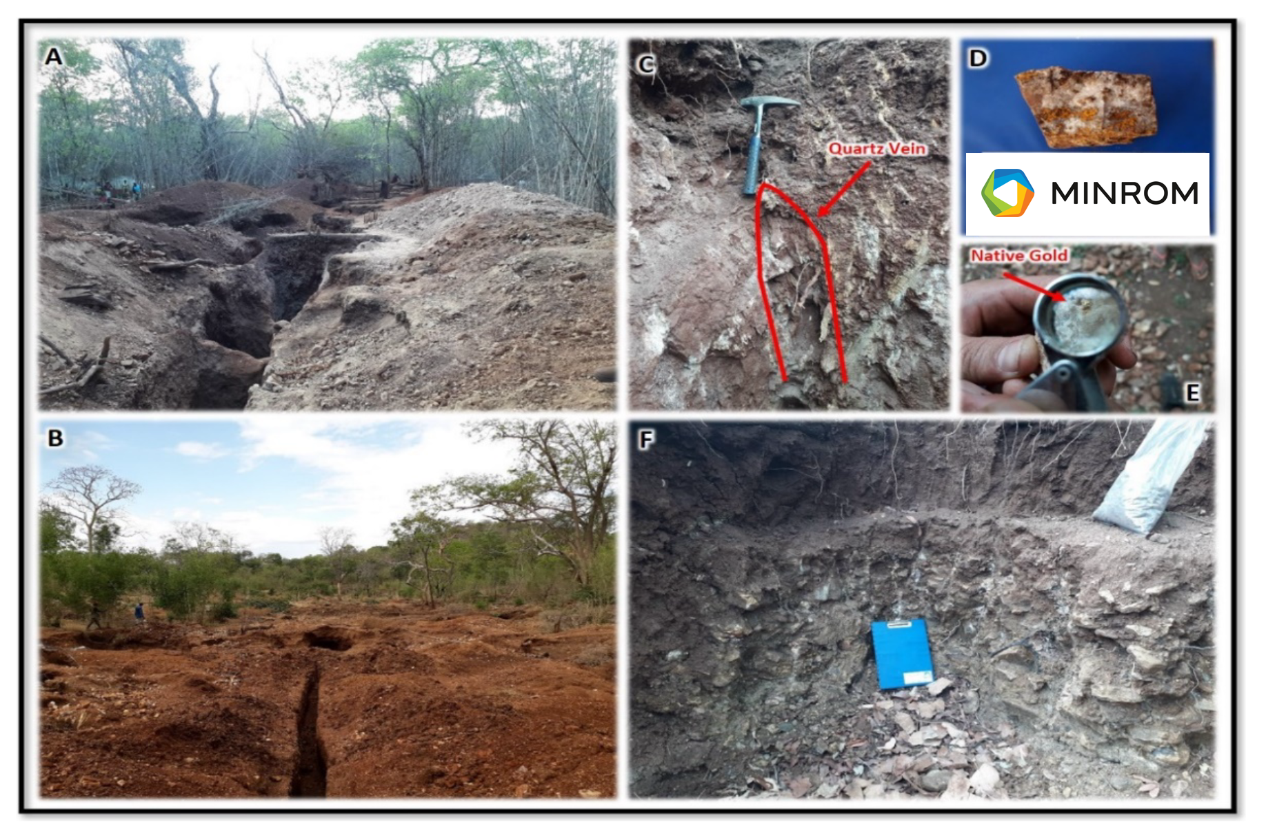
The results of the mapping were so promising that an initial 600 m of diamond drilling and sampling was initiated in August 2015, with the primary aim of determining the in-situ graphitic carbon grades and associated mineral occurrences.
As the full extent of the deposit was still not fully understood, due to the thick vegetation cover in the project area, an electro-magnetic geophysical survey was performed in May of 2016 by Geotech – VTEM. The survey totalled 1078 km of geophysical lines and resulted in numerous large well-developed geophysical anomalies identified across the licence area. These anomalies were systematically investigated in a follow-up Phase 4 trenching programme.
Minrom is currently managing the 5th phase of exploration on the project This phase includes the set-up of an exploration camp, drilling of a water borehole and a total of 1800 m of exploration diamond core drilling, logging, and sampling. Minrom is excited for the outcome of this project. Metallurgical test work and optical microscope work revealed that the graphite deposit can be characterised as a jumbo and large flake deposit that will be mostly free dig operations. Minrom will declare and report a JORC resource on the project in August 2020 for the London listed entity.
The geology of the project area is dominated by the Neoproterozoic West Karamoja Group rocks. This group consists predominantly of basic granulites, garnet-bearing granulites and graphitic granulites. The Neoarchean Amuru Group consisting of gneisses and amphibolites underlies the West Karamoja Group. The Neoproterozoic West Karamoja Group was over thrusted onto the Neoarhean Amuru Group during the Pan-African Orogeny, creating the allochthonous klippe structures. Intrusive bodies are scattered throughout the area. The graphite mineralisation is understood to be a product of the metamorphism of former carbonaceous shales.