


SERVICE: RESOURCE MODELLING & GIS
JORC-Compliant Mineral Resource Estimation and 3D Geological Modelling for Confident Investment Decisions
MINROM Offers These
RESOURCE MODELLING & GIS SERVICES
The key to understanding and analysing
geological data for mineral exploration and mining purposes.
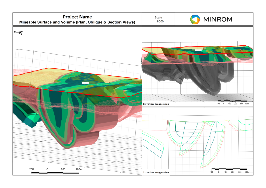
Mineral Resource Estimation is the technical foundation of every investment decision, capital raise, and mine plan in the mining industry. Minrom’s Resource Modelling & GIS service produces resource models, mineral resource estimates, geological models, and spatial datasets that support reporting, planning, and project evaluation. Where required, Mineral Resource Estimates can be prepared to JORC 2012, NI 43-101, and SAMREC reporting standards.
The service covers three interconnected disciplines: mineral resource estimation, 3D geological modelling, and GIS. Mineral resource work includes geological interpretation and block model construction, geostatistical analysis and variography, grade estimation, resource classification, grade-tonnage reporting, Mineral Resource Statements, Competent Person’s Reports, and resource reconciliation.
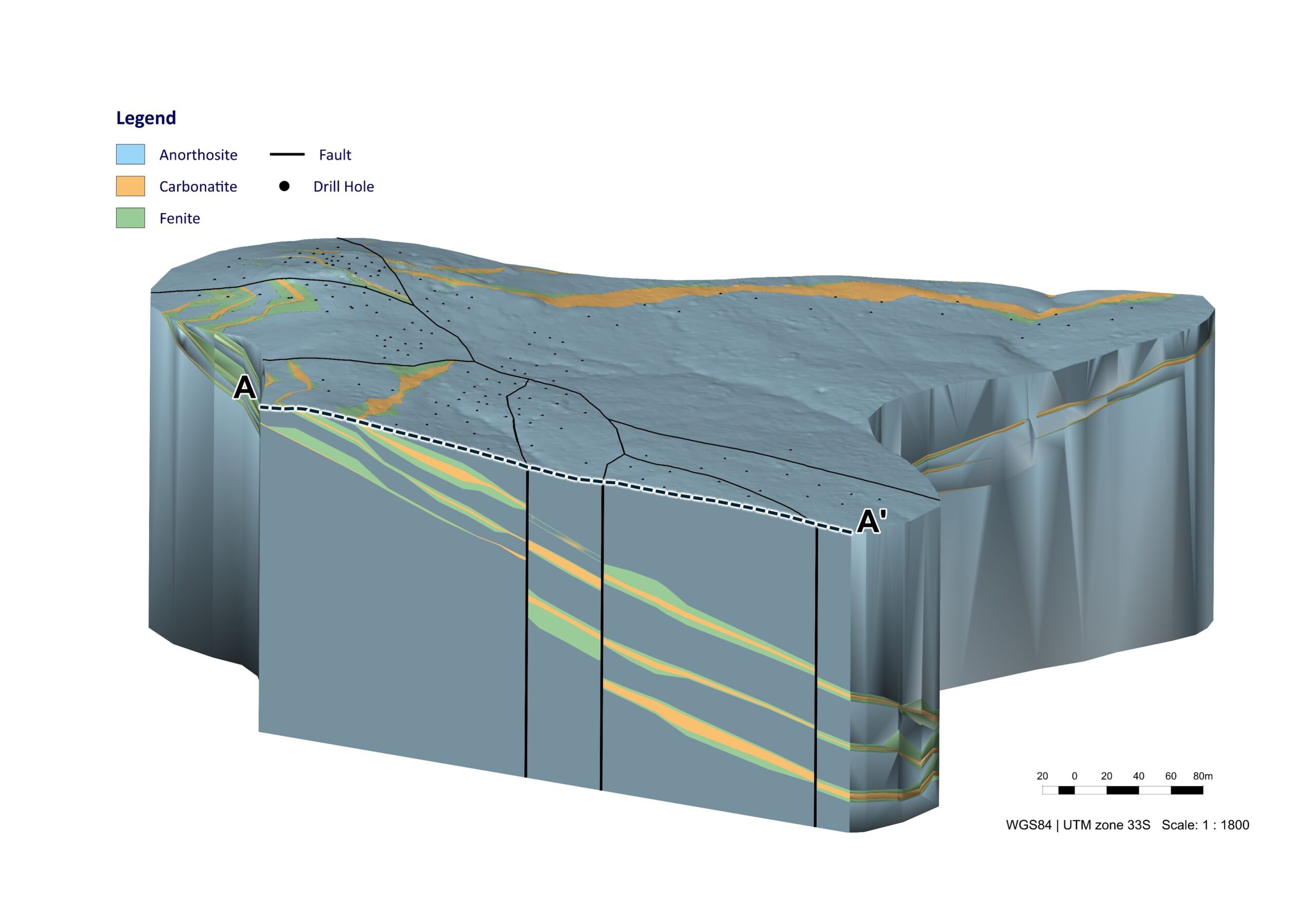
Three-dimensional modelling covers wireframing, implicit and semi-automated explicit geological modelling, drill plan optimisation, and geometallurgical modelling, helping teams understand deposit geometry, ore variability, and metallurgical response.
GIS services include georeferencing, spatial data management, geological map compilation, remote sensing analysis, and geospatial analysis across ArcGIS, QGIS, and project-specific environments. Resource estimation experience covers gold, copper, platinum group metals, manganese, copper-cobalt, graphite, and industrial minerals, with estimation methods selected to match the grade distribution, data spacing, and deposit geometry of each project.
MINERAL RESOURCES
Geostatistically integrate complex datasets (logging, sampling and assay data) to determine the probable and expected grades and tonnages for the deposit. (JORC, NI 43-101, SAMREC)
Block Models
- 3D representations of mineral deposits
- Assign values for mineral content and geological parameters to each block
- Assist in understanding mineral distribution for extraction planning
- Utilise geometallurgy in the model and mine planning environment
Geostatistical Analysis
- Utilize statistical methods to account for spatial variability in geological data.
- Determine accurate and precise mineral resource estimates.
- Support informed decision-making in resource estimation, mine planning, and production management.
Grade-Tonnage Reporting
- Visualize deposit quantity and expected grades after applying specific cut-offs.
- Enable comparison of deposits within the industry.
- Assess potential profitability of mining operations.
Depleting Mining Block Models
- Assist in updating block models to reflect mining progress.
- Ensure accurate representation of evolving deposits.
- Incorporate new data for current models.
Resource Modelling
- Estimate size, grade, and quality of mineral deposits.
- Support informed decisions on mining locations.
- Optimize extraction methods for efficiency and cost-effectiveness.
Mineral Resource Statements
- Classify mineral resource estimates based on geological and statistical confidence.
- Report according to industry standards (e.g., NI 43-101, JORC, SAMREC, SME, PERC).
- Provide essential information about a company’s mineral assets.
Competent Person Reports
- Prepare independent assessments of a company’s mineral assets.
- Base reports on comprehensive geological, technical, and economic data.
- Ensure compliance with specific reporting codes for transparency and accuracy.
Resource Reconciliations (F1 and F4)
- Compare estimated mineral resources with actual production data.
- Identify discrepancies or variations between estimates and production.
- Ensure consistency between resource models and actual production.
- Analyze and optimize resource models and production outcomes.
3D MODELLING
Geological modelling and geometallurgical modelling form the foundation of mineral projects and enable us to:
Drill Plan Optimisation
- Enhance drilling efficiency by targeting high-value zones
- Minimise costs while maximising resource discovery
- Utilise geological data to refine drill hole placement
- Improve accuracy in resource estimation and mine planning
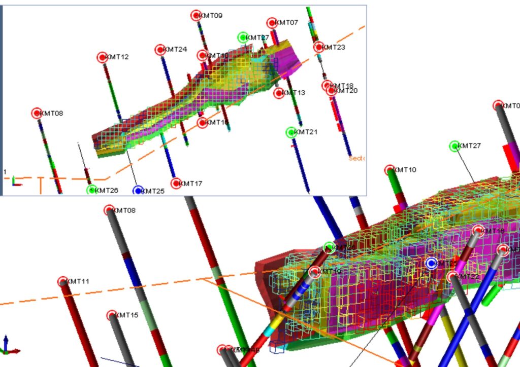
Wireframing
- Creates 3D geological models defining orebody structure
- Outlines mineralised zones based on geological and assay data
- Supports mine planning and block model development
- Provides a visual framework for resource estimation
Implicit Models
- Generate rapid 3D geological interpretations from drill hole data
- Use mathematical algorithms to model complex structures
- Reduce reliance on manual interpretations, increasing accuracy
- Improve decision-making for exploration and mining strategies
Semi-Automated Explicit Models
- Combine manual and automated modelling for efficient 3D geological interpretations
- Increase accuracy and consistency in orebody modelling
- Allow geologists to refine models based on real-time exploration data
- Improve resource estimation and mine planning decisions
Geometallurgical Models
- Integrate geological and metallurgical data to predict ore processing behaviour
- Enhance mineral recovery and processing efficiency based on ore characteristics and geospatial relationships
- Support cost-effective mine planning by optimising resource utilisation
- Reduce processing risks by identifying ore variability early
GIS SERVICES
Geographic information systems (GIS) involve the analysis of all spatial data, enabling the identification of patterns and trends.
Georeferencing
- Assigns geographic coordinates to digital images
- Enables accurate positioning on Earth’s surface
- Facilitates integration with other geographic data
Digitisation/Vectorisation
- Conversion of georeferenced images into vector data (points, lines, polygons)
- Trace desired features for digital utilisation
- Transition from hard copy to digital formats
Digital Maps/Plans
- Development of virtual representations incorporating desired data
- Provision of accurate depictions of areas
- Highlight important features visually
Terrain Analysis
- Used to interpret and analyse topographic features (slope, aspect, elevation, contours)
- Used for hydrological mapping, land component mapping, and elevation mapping
- Assess accessibility and identify potential target areas
Regional & Structural Trend Mapping
- Identification of geological trends and structural frameworks
- Used to understand crustal movements shaping current terrain
- Support the interpretation of local structures
Photogrammetry & Orthomosaic Processing
- Creation of 3D models from a series of photographs
- Generation of rectified overhead imagery at uniform scales
- Utilise drones for high-resolution 2D and 3D mapping
Drone Data DTM/DEM Processing
- Generation of Digital Terrain Models (DTMs) and Digital Elevation Models (DEMs) from drone data
- Used to calculate volumes, surface areas, and measure changes
- Effective spatial data analysis
Remote Sensing
- Remote detection and monitoring of physical characteristics of areas
- Use of satellite or aircraft imagery to measure reflected and emitted radiation
- Used to identify mineral target areas over large regions
- Exploration costs significantly reduced
Smarter Mining Begins with Accurate Resource Modelling
Enhance accuracy, reduce risk, and optimise your mining strategy with expert resource modelling and GIS services.
Resource Modelling & GIS Services Frequently Asked Questions
Geological modelling builds a structured picture of the subsurface using drilling, mapping, sampling, structural data, and geological interpretation. In mining, 3D geological modelling supports resource modelling mining, mine planning, risk review, and better decisions about where mineralisation is likely to continue.
A 3D geological model is a digital representation of the subsurface. It shows rock types, structures, mineralised zones, and grade distribution in three dimensions. A geological block model, subsurface modelling, and mining 3D modelling help teams visualise the deposit and plan further exploration or mining work.
Mineral resource estimation accuracy depends on reliable sampling, quality drilling data, geological consistency, sound interpretation, and appropriate estimation methods. Resource estimation accuracy improves through geological data validation, database checks, QA/QC review, geostatistical analysis, and mineral resource modelling that reflects the real deposit geometry.
Geological data mining for modelling usually includes drillhole data, assays, lithology, structures, density, topography, geochemistry, geophysics, and mapping. Exploration data mining and geostatistical data mining help geologists interpret patterns, test continuity, and build models that support resource estimation and mine planning.
GIS in mining helps teams organise, analyse, and visualise spatial data. Common GIS mining applications include target generation, mapping in mining projects, drill planning, access assessment, environmental overlays, infrastructure planning, and spatial data mining across geology, sampling, terrain, water, and land-use datasets.