


CASE STUDY
Namibian Iron Ore Deposits
Scope of Work
Overview
Minrom Consulting commenced with project management and exploration on this project since 2012 delivering a final CPR report for this prominent iron ore project in Namibia.
The CPR included data from seven exploration phases, involving airborne and ground geophysical surveys, geological mapping, drilling, and various studies. Following Phase 7 exploration, it was confirmed that a high product grade can be achieved.
Commodity
Iron Ore, hematite (Fe 2 O 3 )
Country
Namibia
Project Type
Competent Person's Report

Minrom Consulting was contracted to prepare an independent Competent Persons Report (CPR) on a well-known iron ore project in Namibia. The report provided a summary of all the relevant data that was compiled and processed to generate a Mineral Resource Estimate (MRE).
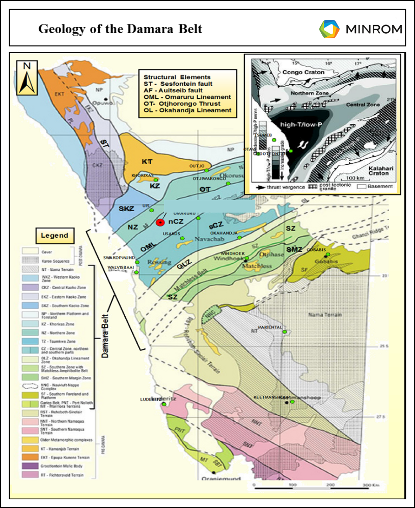
This iron ore project is situated within the geologically renowned Damara Belt. This belt formed from a series of rifting, convergence, and collisional events that produced five (5) distinct NE-trending tectono-metamorphic, orogen strike-parallel zones with the zone of interest for this project being the Southern Marginal Zone (Figure 1).
Regional Geology
The banded iron formations (BIFs) being targeted for this project are commonly known as the Khomas Itabrites, with itabrite being a term used to describe banded quartz hematites or hematite schists. The Khomas Itabrites are found in the Naos Formation of the Hakos Group and extend over 200 km along strike of the belt, with the maximum width of the belt where these units occur being 40 km. These BIFs were deposited between 650 and 630 Ma and subsequently underwent amphibolite facies metamorphism during the Damara Orogeny.
As part of the CPR, Minrom compiled all the data received and gathered from seven phases of exploration programmes performed by Minrom. The exploration work undertaken included airborne and ground geophysical surveys, geological mapping, drilling as well as metallurgical and geochemical studies. The data utilised to generate the MRE and range analysis included lithological and structural data obtained from field mapping, field sample data, drilling information, preliminary ore characterisations, and metallurgical test results.
In total, some 12,000 metres of drilling were done, with 7000 samples submitted for chemical analysis. From the initial database, 5000 samples were analysed for magnetic content, improving the accuracy of the model. The resultant block models for the two orebodies illustrate the distribution of the different mineralisation components from geo-metallurgical characterisation in 3D space (Figure 2). These models provide critical information that allows for effective planning of the next project phases and adding NPV to the previous models.
Figure 1
Geology of the Damara Belt. SMZ indicates the Southern Marginal Zone.
Regional Geology
Figure 1
Geology of the Damara Belt. SMZ indicates the Southern Marginal Zone.
The banded iron formations (BIFs) being targeted for this project are commonly known as the Khomas Itabrites, with itabrite being a term used to describe banded quartz hematites or hematite schists. The Khomas Itabrites are found in the Naos Formation of the Hakos Group and extend over 200 km along strike of the belt, with the maximum width of the belt where these units occur being 40 km. These BIFs were deposited between 650 and 630 Ma and subsequently underwent amphibolite facies metamorphism during the Damara Orogeny.
As part of the CPR, Minrom compiled all the data received and gathered from seven phases of exploration. The exploration work undertaken included airborne and ground geophysical surveys, geological mapping, drilling as well as metallurgical and geochemical studies. The data utilised to generate the MRE and range analysis included lithological and structural data obtained from field mapping, field sample data, drilling information, preliminary ore characterisations, and metallurgical test results.
In total, 11,916.82 metres of drilling was done over 105 drill holes with 4,898 samples submitted for chemical analysis. From the initial database, 1500 samples were re-analysed for magnetic content to help improve the accuracy of the model. The geostatistical estimation concentrated on Satmagan models and is based on magnetic iron content. The resultant block models for the Southern and Northern orebodies illustrates the distribution of magnetite and iron content in 3D space (Figure 2). These models provide critical information that allow for effective planning of the next project phases.
Photographic Data
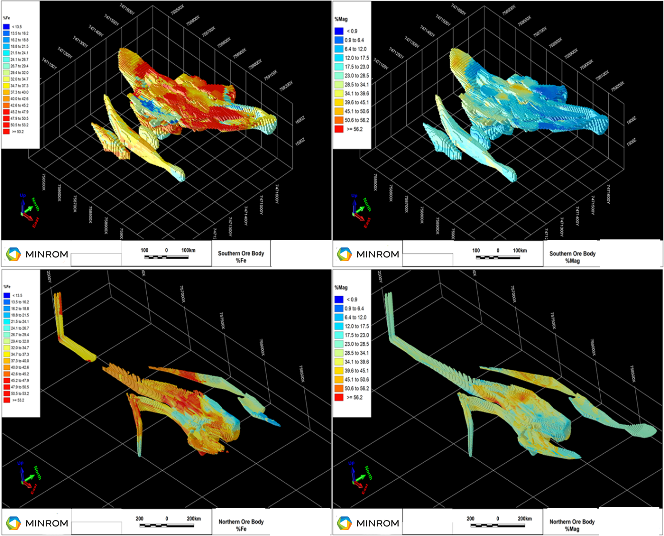
Figure 2
Iron Ore Project in Namibia 3-dimensional block models.
With the completion of Phase 7 exploration, confirmed that a high percentage of product grade can be achieved. Minrom is proud to be a part of this ongoing iron ore project and are excited by the current mining progress. The company looks forward to future endeavours with our client.
Photographic Data
With the completion of 7 phases of exploration, Minrom can confirm that a high percentage of product grade can be achieved and this is the next big super high grade mine in the SADC region, a great green iron project. Minrom is proud to be a part of this ongoing iron ore project and are excited by the current project progress.