

Minrom’s strategy service aims to unlock the value of a project by integrating geological and metallurgical ore characteristics, mine planning and environmental drivers of ore deposits.
Minrom’s Exploration services identify and evaluate mineral deposits using advanced geological exploration techniques to maximise discovery potential and investment returns.
Minrom’s Modelling and GIS services integrate complex geological data, structural data and geometallurgical data into well-informed optimised mine plans, driving the increase in NPV.

Minrom’s Mining Geology services deliver expert integration of mine planning and grade control practices and delivers efficient ore extraction, grade control and reserve reconciliation to maximise mining efficiency.
Minrom’s Hydrology services specialise in groundwater detection, quantification, management, and sustainability solutions to support mining operations and environmental compliance.

Minrom’s Training programmes equip professionals with hands-on skills in mineral exploration, resource estimation, geological mapping, mine planning, and mining 101 for real-world mining applications.

Minrom is committed to sustainable impact through various corporate social responsibility initiatives: supporting education, community development, environmental conservation, and industry growth.
Minrom’s dedicated NGO empowers the ‘little voices’ (primary school children) by funding ECD teacher training, supplying school material, mentorship, and supporting upliftment and aid initiatives.
Showcasing and supporting local artistic talent through collaborations to celebrate the connection between art, community, and mining.
Our Box of Rocks, inspiring the next generation of geologists through interactive learning.

Raising awareness for rare diseases through initiatives like the Poetry Project, giving a voice to those affected.
Minrom supports the National Sea Rescue Institute (NSRI) who protect communities along South Africa’s coastline. The NSRI is the only open water body rescue service in RSA and is solely funded by donations.

Showcase the splendour of the Overberg Geotrail, promoting geotourism, education and the conservation of SA’s geological landscapes.
Minrom funds and facilitates borehole projects to provide clean, sustainable water sources for isolated communities and schools in need.

We invest in industry growth by offering geological software training, equipping aspiring mining professionals.
Minrom’s strategy service aims to unlock the value of a project by integrating geological and metallurgical ore characteristics, mine planning and environmental drivers of ore deposits.
Minrom’s Exploration services identify and evaluate mineral deposits using advanced geological exploration techniques to maximise discovery potential and investment returns.
Minrom’s Modelling and GIS services integrate complex geological data, structural data and geometallurgical data into well-informed optimised mine plans, driving the increase in NPV.
Minrom’s Mining Geology services deliver expert integration of mine planning and grade control practices and delivers efficient ore extraction, grade control and reserve reconciliation to maximise mining efficiency.
Minrom’s Hydrology services specialise in groundwater detection, quantification, management, and sustainability solutions to support mining operations and environmental compliance.
Minrom’s Training programmes equip professionals with hands-on skills in mineral exploration, resource estimation, geological mapping, mine planning, and mining 101 for real-world mining applications.
Minrom is committed to sustainable impact through various corporate social responsibility initiatives: supporting education, community development, environmental conservation, and industry growth.
Minrom’s dedicated NGO empowers the ‘little voices’ (primary school children) by funding ECD teacher training, supplying school material, mentorship, and supporting upliftment and aid initiatives.
Showcasing and supporting local artistic talent through collaborations to celebrate the connection between art, community, and mining.
Our Box of Rocks, inspiring the next generation of geologists through interactive learning.
Raising awareness for rare diseases through initiatives like the Poetry Project, giving a voice to those affected.
Minrom supports the National Sea Rescue Institute (NSRI) who protect communities along South Africa’s coastline. The NSRI is the only open water body rescue service in RSA and is solely funded by donations.
Showcase the splendour of the Overberg Geotrail, promoting geotourism, education and the conservation of SA’s geological landscapes.
Minrom funds and facilitates borehole projects to provide clean, sustainable water sources for isolated communities and schools in need.
We invest in industry growth by offering geological software training, equipping aspiring mining professionals.
Minrom supported a lime mining operation in Limpopo Province by reviewing historical drilling and sampling data, building a preliminary 3D geological model, and completing a follow-up pitting program. The work helped refine calcium carbonate mineralization, grade distribution, mineable zones, and Life of Mine estimates for industrial and agricultural lime production.
Minrom has been actively involved in developing and executing an exploration strategy at a prominent animal feed lime mine in the Limpopo Province of South Africa. The project produces both industrial and agricultural grade lime products Lime is one of the most important industrial commodities and is used in several different industries.
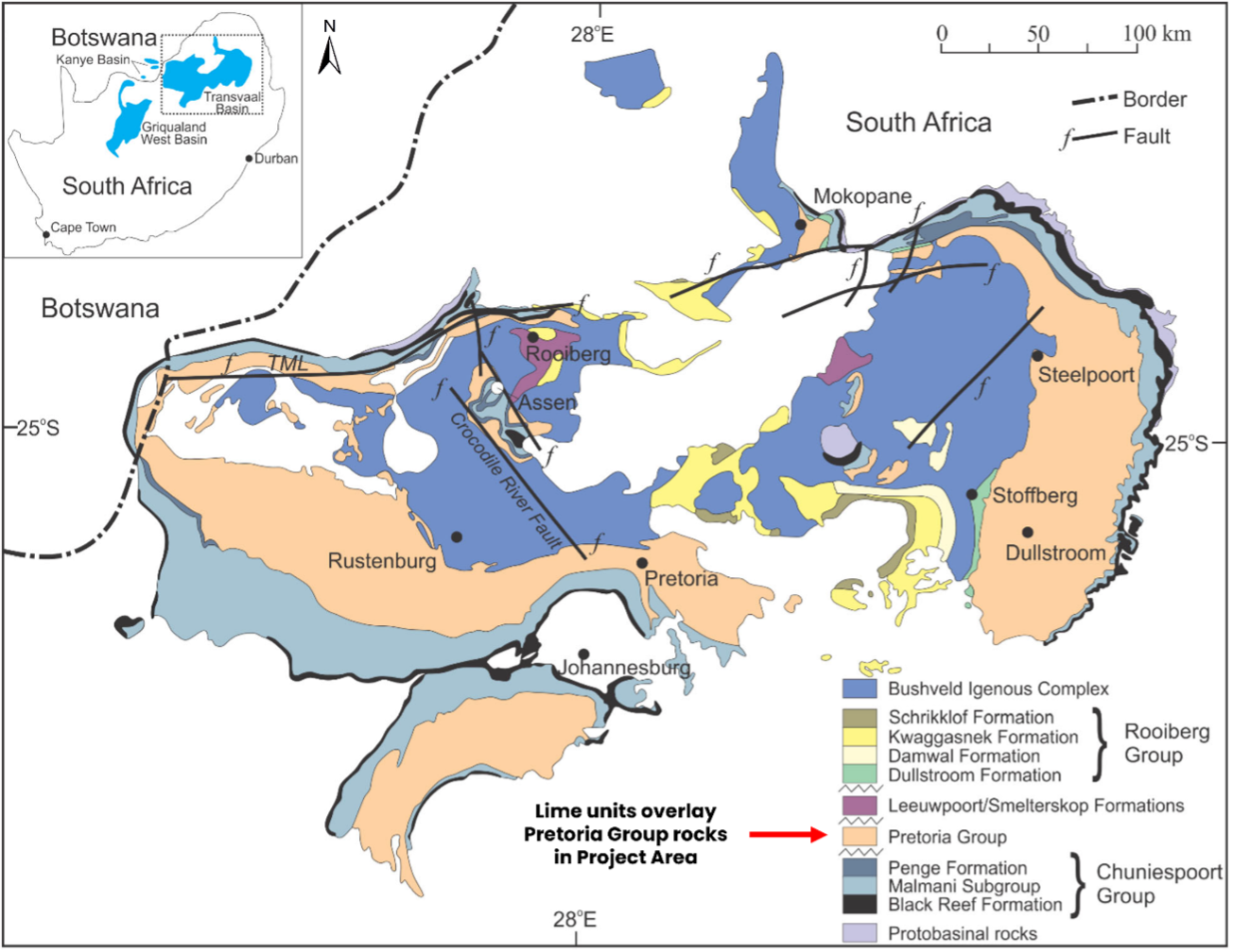
The geology associated with the project area consists of the rocks of the Pretoria Group (Transvaal Supergroup) unconformably overlain by tertiary to quaternary age sediments. These sediments contain the CaCO3 mineralisation which is hosted in thick (3-12 m) calcrete beds . These beds contain calcium carbonate grades of 60 – 90% CaCO3. The higher the grade, the greater the purity of the lime aggregate produced.
For this project, Minrom’s role was to help the client better understand the resource base, refine mineralization estimates, and support Life of Mine planning.
Minrom performed a mineralisation quantification based on previous historical diamond and Reverse circulation drilling and sampling data for the Mining Rights area. This included the development of a preliminary 3D geological model for the deposit.
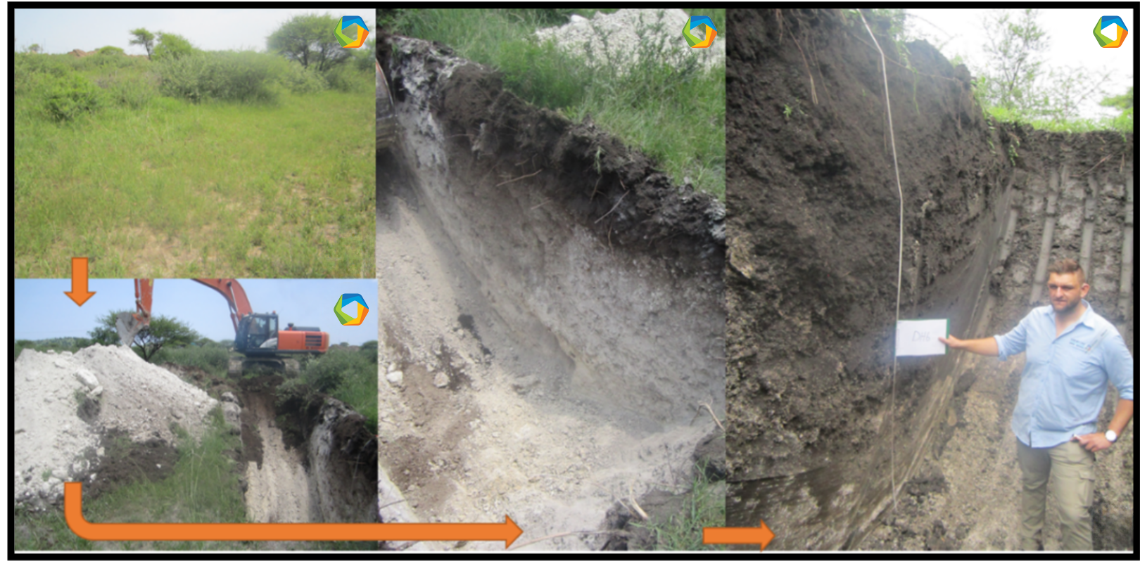
Minrom performed a follow-up pitting programme within the mine area to investigate the profiles of the subsurface geology and update the previous mineralisation estimates. .
The aim was to refine the mineralisation, grade and Life of Mine (LOM). Th pitting allowed Minrom to develop of various models considering different mineable zones, varying depths, and with several ranges of cut-off grades. This helped minimise the risk of mining blindly and optimised the mining process for our client!
Minrom performed a follow-up pitting programme within the mine area to investigate the profiles of the subsurface geology and update the previous mineralisation estimates.
The aim was to refine the mineralisation, grade and Life of Mine (LOM). Th pitting allowed Minrom to develop of various models considering different mineable zones, varying depths, and with several ranges of cut-off grades. This helped minimise the risk of mining blindly and optimised the mining process for our client!