

Minrom’s strategy service aims to unlock the value of a project by integrating geological and metallurgical ore characteristics, mine planning and environmental drivers of ore deposits.
Minrom’s Exploration services identify and evaluate mineral deposits using advanced geological exploration techniques to maximise discovery potential and investment returns.
Minrom’s Modelling and GIS services integrate complex geological data, structural data and geometallurgical data into well-informed optimised mine plans, driving the increase in NPV.

Minrom’s Mining Geology services deliver expert integration of mine planning and grade control practices and delivers efficient ore extraction, grade control and reserve reconciliation to maximise mining efficiency.
Minrom’s Hydrology services specialise in groundwater detection, quantification, management, and sustainability solutions to support mining operations and environmental compliance.

Minrom’s Training programmes equip professionals with hands-on skills in mineral exploration, resource estimation, geological mapping, mine planning, and mining 101 for real-world mining applications.

Minrom is committed to sustainable impact through various corporate social responsibility initiatives: supporting education, community development, environmental conservation, and industry growth.
Minrom’s dedicated NGO empowers the ‘little voices’ (primary school children) by funding ECD teacher training, supplying school material, mentorship, and supporting upliftment and aid initiatives.
Showcasing and supporting local artistic talent through collaborations to celebrate the connection between art, community, and mining.
Our Box of Rocks, inspiring the next generation of geologists through interactive learning.

Raising awareness for rare diseases through initiatives like the Poetry Project, giving a voice to those affected.
Minrom supports the National Sea Rescue Institute (NSRI) who protect communities along South Africa’s coastline. The NSRI is the only open water body rescue service in RSA and is solely funded by donations.
Showcase the splendour of the Overberg Geotrail, promoting geotourism, education and the conservation of SA’s geological landscapes.
Minrom funds and facilitates borehole projects to provide clean, sustainable water sources for isolated communities and schools in need.

We invest in industry growth by offering geological software training, equipping aspiring mining professionals.
Minrom’s strategy service aims to unlock the value of a project by integrating geological and metallurgical ore characteristics, mine planning and environmental drivers of ore deposits.
Minrom’s Exploration services identify and evaluate mineral deposits using advanced geological exploration techniques to maximise discovery potential and investment returns.
Minrom’s Modelling and GIS services integrate complex geological data, structural data and geometallurgical data into well-informed optimised mine plans, driving the increase in NPV.
Minrom’s Mining Geology services deliver expert integration of mine planning and grade control practices and delivers efficient ore extraction, grade control and reserve reconciliation to maximise mining efficiency.
Minrom’s Hydrology services specialise in groundwater detection, quantification, management, and sustainability solutions to support mining operations and environmental compliance.
Minrom’s Training programmes equip professionals with hands-on skills in mineral exploration, resource estimation, geological mapping, mine planning, and mining 101 for real-world mining applications.
Minrom is committed to sustainable impact through various corporate social responsibility initiatives: supporting education, community development, environmental conservation, and industry growth.
Minrom’s dedicated NGO empowers the ‘little voices’ (primary school children) by funding ECD teacher training, supplying school material, mentorship, and supporting upliftment and aid initiatives.
Showcasing and supporting local artistic talent through collaborations to celebrate the connection between art, community, and mining.
Our Box of Rocks, inspiring the next generation of geologists through interactive learning.
Raising awareness for rare diseases through initiatives like the Poetry Project, giving a voice to those affected.
Minrom supports the National Sea Rescue Institute (NSRI) who protect communities along South Africa’s coastline. The NSRI is the only open water body rescue service in RSA and is solely funded by donations.
Showcase the splendour of the Overberg Geotrail, promoting geotourism, education and the conservation of SA’s geological landscapes.
Minrom funds and facilitates borehole projects to provide clean, sustainable water sources for isolated communities and schools in need.
We invest in industry growth by offering geological software training, equipping aspiring mining professionals.
At Minrom we specialise in 3D mining modelling that leads to maximising mineral resource discovery and extraction in existing and new mining projects. Our resource modelling and GIS solutions cover every stage, from data acquisition and analysis to exploration.
Get in touch
Understanding the spatial variability of a deposit to generate the optimal drill hole spacing. This reduces the number of drilling holes needed to gain the maximum amount of geological data. Drilling operations can achieve better results and maximize their return on investment.
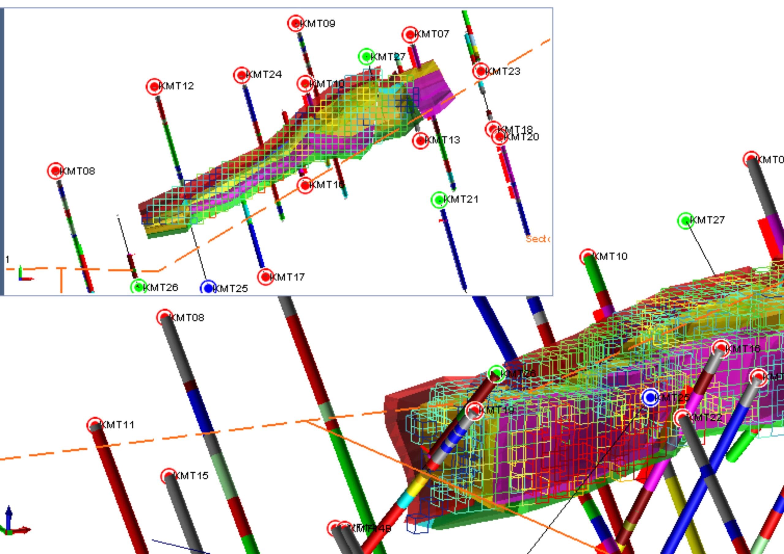
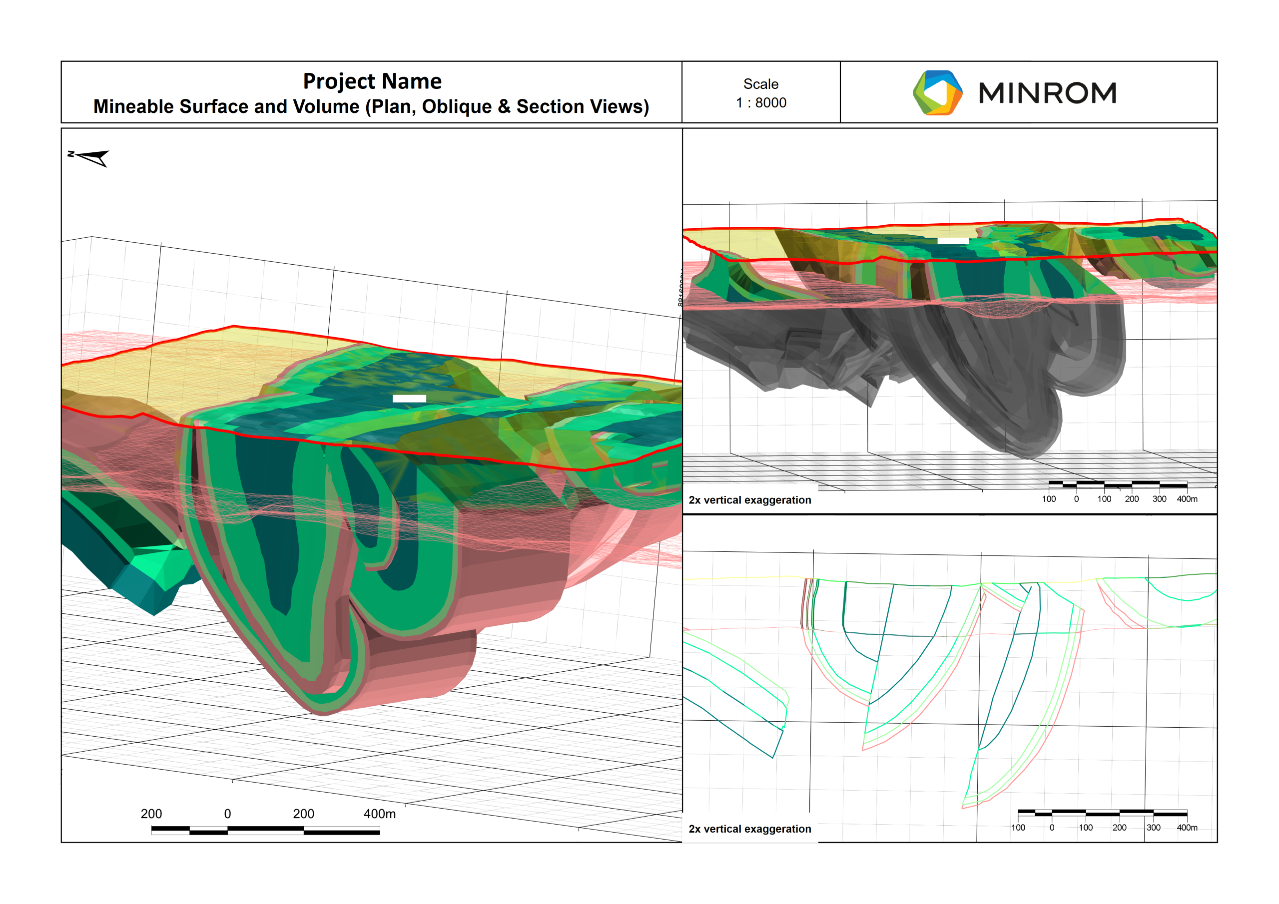
Wireframes allow geologists to create accurate 3D representations of subsurface rock formations, faults, and other geological features. By visualizing these structures in 3D geologists can better understand the geology of a region, make more informed decisions about resource exploration, and optimize drilling and mining operations.
The biggest asset of an exploration programme is a validated and well-presented geological and geospatial database. At MINROM we ensure that your data is centralised, complies with international quality standards and is safely stored.
Semi-automated explicit geological models takes the best of both implicit (rapid) and explicit (interpretation based) models. This unique method allows for complex geological models to be quickly updated with new data.
A geometallurgical model is a comprehensive framework that integrates geological and metallurgical information to predict the behaviour of ore deposits throughout the mining and processing stages.