


















CASE STUDY
Field Mapping and Sampling for Lithium, Tantalum and Tin Pegmatite Mineral Exploration in Masvingo Province, Zimbabwe
Project overview
Minrom was contracted by a pegmatite mining group to conduct a geological surface mapping and sampling programme on the pegmatite occurrences within their claim rights. The project is located within four claim areas Masvingo Province of Zimbabwe.
Scope of Work
Key takeaways
- The project focuses on lithium and 3T pegmatite occurrences within four (4) claim areas in Masvingo Province, Zimbabwe.
- Minrom conducted surface mapping and a sampling programme across the claim and surrounding areas.
- Lithological outcrops were recorded, revealing numerous pegmatite occurrences.
- The investigation revealed zonation in the pegmatites, showing compositional and grade variations.
- Hand samples indicated occurrences of tantalum (Ta) and niobium (Nb) alongside mica-rich, oxide, and petalite-bearing zones.
Commodity
Pegmatite
Country
Zimbabwe (Masvingo Province)
Project Type
Mineral Exploration and Surface Mapping

Project Geological Context
Zimbabwe is situated predominantly on Zimbabwe Craton. The Zimbabwe Craton experienced tectonic activity due to the collision between itself and the Kaapvaal Craton forming the Limpopo Belt approximately 2.7 Ga years ago. A cratonic terrain comprises predominantly granitic and gneissic basement rocks along with greenstone belt occurrences.
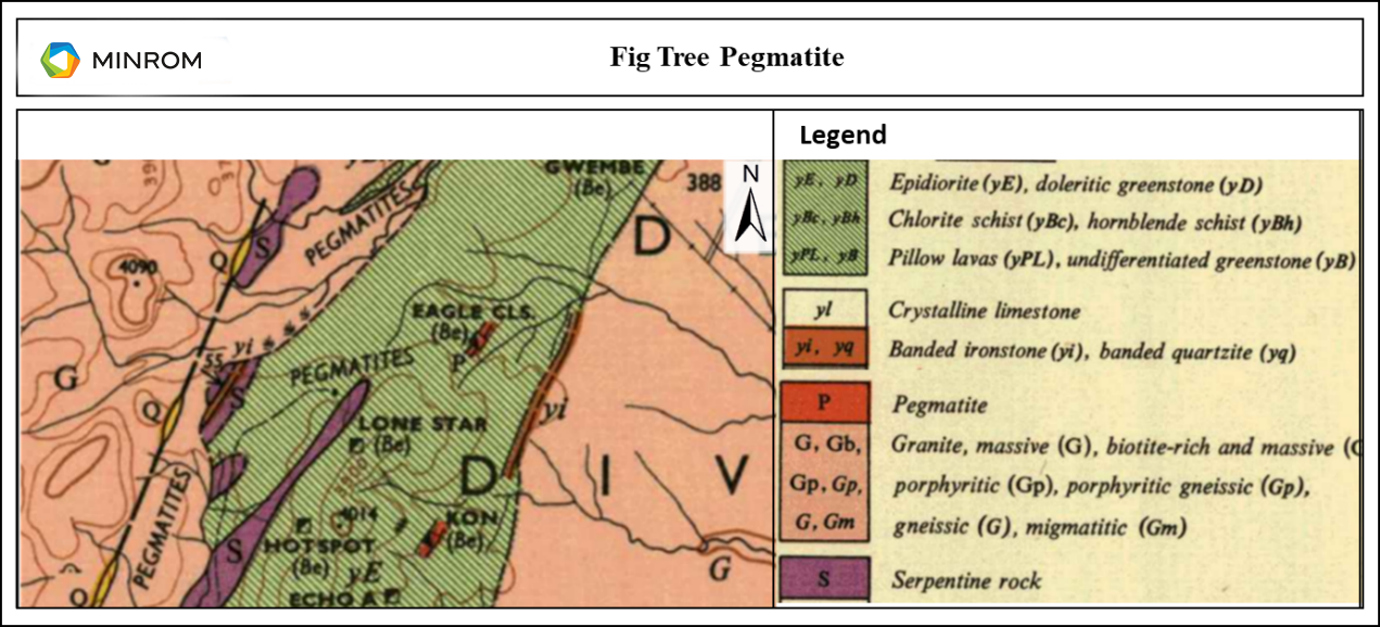
The project area is situated within the Victoria Greenstone Belt. The Victoria Greenstone Belt outcrops periodically in the southeastern part of Zimbabwe. The southern greenstone belt is partly covered by sedimentary units of the Umkondo and Karoo system. The basement complex forms a large amount of the surface geology in the area. The Fig Tree pegmatite area contains a considerable amount of tantalite, niobium and tungsten concentrations.
Minrom’s Technical Involvement
Minrom conducted a geological surface mapping and sampling programme. As part of the investigation, Minrom traversed the claim and surrounding areas to determine the lateral extent of the pegmatite occurrences and possible zonation. All lithological outcrops were recorded along with relevant geological information (Figure 2).
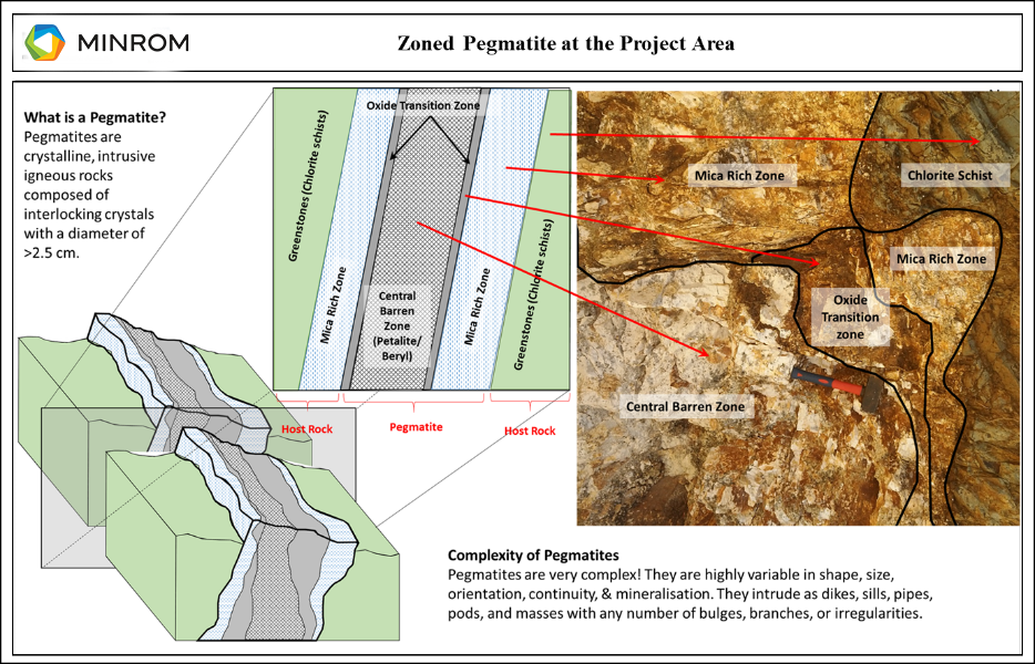
During the mapping programme, numerous pegmatite outcrops were encountered. A detailed investigation of the pegmatites revealed that zonation is present in the pegmatites and is characterised by compositional and slight grade variations. The zonation patterns are to be defined, in detail through drilling.
Figure 1
General Geology of the Project Location.
In order to present the client with a high-level tonnage estimate a high-level geological model was constructed. Minrom found potential pegmatite mineralisation obtained from the generated data.
Figure 2
Zoned Pegmatite at the Project Area.
Key Findings and Recommendations:
- A detailed investigation of the lithium and 3T pegmatites revealed that zonation is present, characterised by compositional and slight grade variations.
- These zonation patterns are to be defined in detail through future drilling operations.
- Minrom recommended that the client scope, plan and develop a Phase 2 drilling programme supported by 10 diamond drill holes to further investigate the resource.
- Additionally, Minrom recommends that metallurgical analysis will be conducted to determine the liberation and optimal recovery methods required for the project.
Figure 3
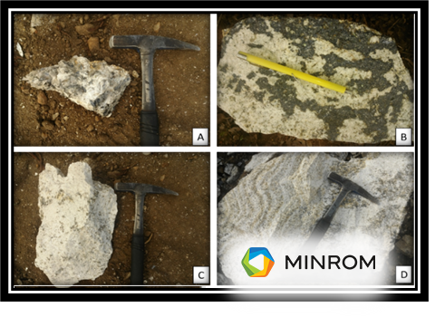
A) Hand sample from the mica rich pegmatite zone. B) Pegmatite sample from the oxide zone of the pegmatite. C) Pegmatite sample from the barren zone of the pegmatite likely containing lesser amounts of Petalite. D) Contact point between the mica rich zone (right) and the oxide zone (left).
Project Geological Context
Zimbabwe is situated predominantly on Zimbabwe Craton. The Zimbabwe Craton experienced tectonic activity due to the collision between itself and the Kaapvaal Craton forming the Limpopo Belt approximately 2.7 Ga years ago. A cratonic terrain comprises predominantly granitic and gneissic basement rocks along with greenstone belt occurrences.
The project area is situated within the Victoria Greenstone Belt. The Victoria Greenstone Belt outcrops periodically in the southeastern part of Zimbabwe. The southern greenstone belt is partly covered by sedimentary units of the Umkondo and Karoo system. The basement complex forms a large amount of the surface geology in the area. The Fig Tree pegmatite area contains a considerable amount of tantalite, niobium and tungsten concentrations.
Figure 1
General Geology of the Project Location.
Minrom’s Technical Involvement
Minrom conducted a geological surface mapping and sampling programme. As part of the investigation, Minrom traversed the claim and surrounding areas to determine the lateral extent of the pegmatite occurrences and possible zonation. All lithological outcrops were recorded along with relevant geological information (Figure 2).
During the mapping programme, numerous pegmatite outcrops were encountered. A detailed investigation of the pegmatites revealed that zonation is present in the pegmatites and is characterised by compositional and slight grade variations. The zonation patterns are to be defined, in detail, through drilling.
Figure 2
Zoned Pegmatite at the Project Area.
In order to present the client with a high-level tonnage estimate a high-level geological model was constructed. Minrom found potential pegmatite mineralisation obtained from the generated data.
Figure 3
A) Hand sample from the mica rich pegmatite zone. B) Pegmatite sample from the oxide zone of the pegmatite. C) Pegmatite sample from the barren zone of the pegmatite likely containing lesser amounts of Petalite. D) Contact point between the mica rich zone (right) and the oxide zone (left).
Key Findings and Recommendations:
- A detailed investigation of the lithium and 3T pegmatites revealed that zonation is present, characterised by compositional and slight grade variations.
- These zonation patterns are to be defined in detail through future drilling operations.
- Minrom recommended that the client scope, plan and develop a Phase 2 drilling programme supported by 10 diamond drill holes to further investigate the resource.
- Additionally, Minrom recommends that metallurgical analysis will be conducted to determine the liberation and optimal recovery methods required for the project.