


Turning Data into Decisions through Geological Modelling and Geostatistics
SERVICES
Geological modelling and geospatial analyses play a crucial role in understanding and analysing geological data for mineral exploration and mining purposes. MINROM offers a range of services related to geological modelling, mineral resource estimations, and GIS analyses.
RESOURCE MODELLING & GIS
What we offer
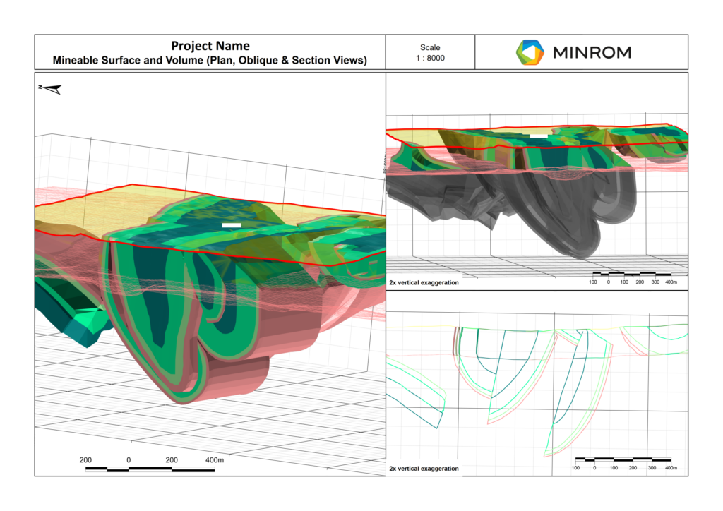
MINERAL RESOURCES
Geostatistically integrate complex datasets (logging, sampling and assay data) to determine the probable and expected grades and tonnages for the deposit. (JORC, NI 43-101, SAMREC)
Block Models
- 3D representations of mineral deposits
- Assign values for mineral content and geological parameters to each block
- Assist in understanding mineral distribution for extraction planning
- Utilise geometallurgy in the model and mine planning environment
Geostatistical Analysis
- Utilize statistical methods to account for spatial variability in geological data.
- Determine accurate and precise mineral resource estimates.
- Support informed decision-making in resource estimation, mine planning, and production management.
Grade-Tonnage Reporting
- Visualize deposit quantity and expected grades after applying specific cut-offs.
- Enable comparison of deposits within the industry.
- Assess potential profitability of mining operations.
Depleting Mining Block Models
- Assist in updating block models to reflect mining progress.
- Ensure accurate representation of evolving deposits.
- Incorporate new data for current models.
Resource Modelling
- Estimate size, grade, and quality of mineral deposits.
- Support informed decisions on mining locations.
- Optimize extraction methods for efficiency and cost-effectiveness.
Mineral Resource Statements
- Classify mineral resource estimates based on geological and statistical confidence.
- Report according to industry standards (e.g., NI 43-101, JORC, SAMREC, SME, PERC).
- Provide essential information about a company’s mineral assets.
Competent Person Reports
- Prepare independent assessments of a company’s mineral assets.
- Base reports on comprehensive geological, technical, and economic data.
- Ensure compliance with specific reporting codes for transparency and accuracy.
Resource Reconciliations (F1 and F4)
- Compare estimated mineral resources with actual production data.
- Identify discrepancies or variations between estimates and production.
- Ensure consistency between resource models and actual production.
- Analyze and optimize resource models and production outcomes.
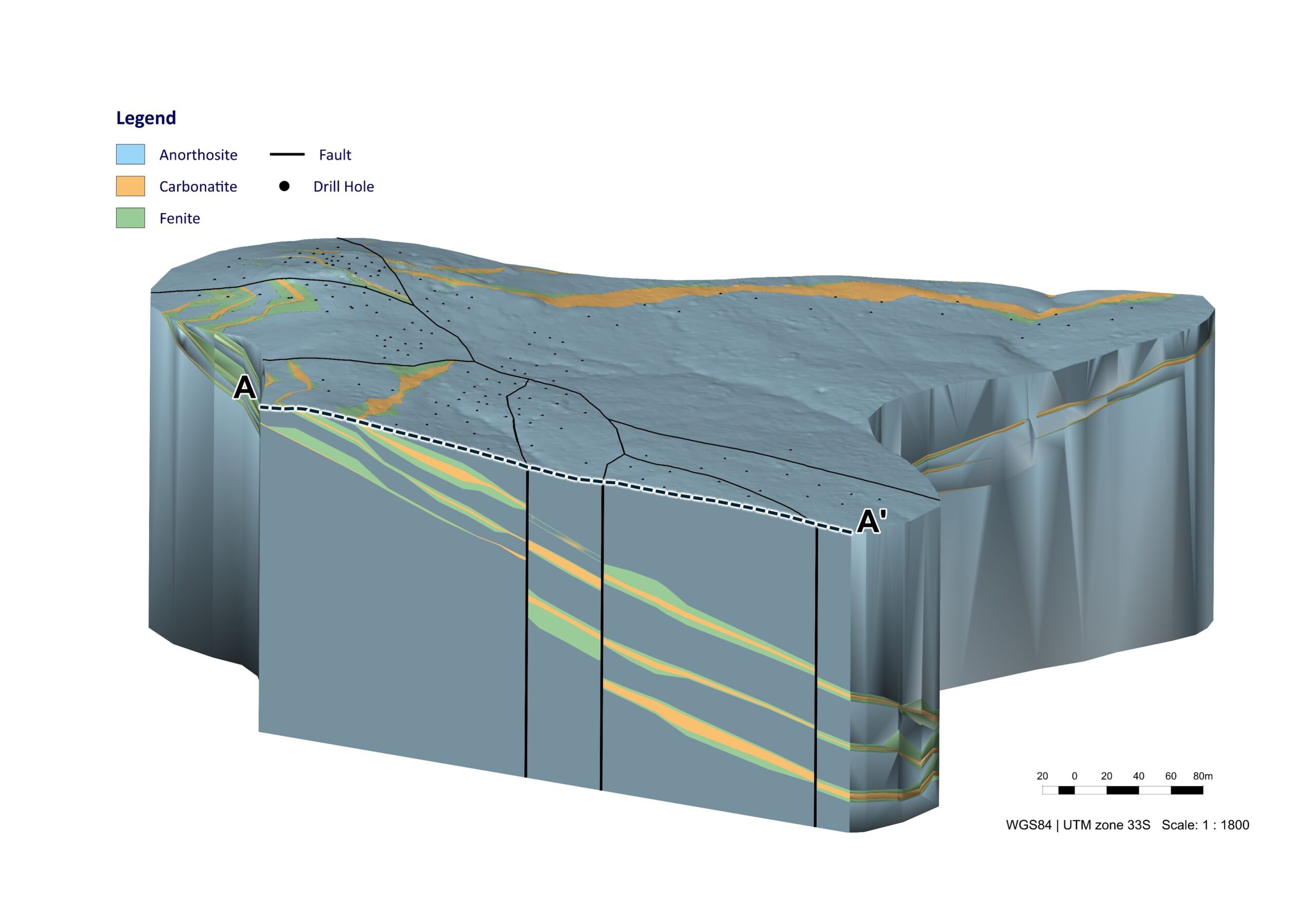
3D MODELLING
Geological modelling and geometallurgical modelling form the foundation of mineral projects and enable us to:
Drill Plan Optimisation
- Enhance drilling efficiency by targeting high-value zones
- Minimise costs while maximising resource discovery
- Utilise geological data to refine drill hole placement
- Improve accuracy in resource estimation and mine planning
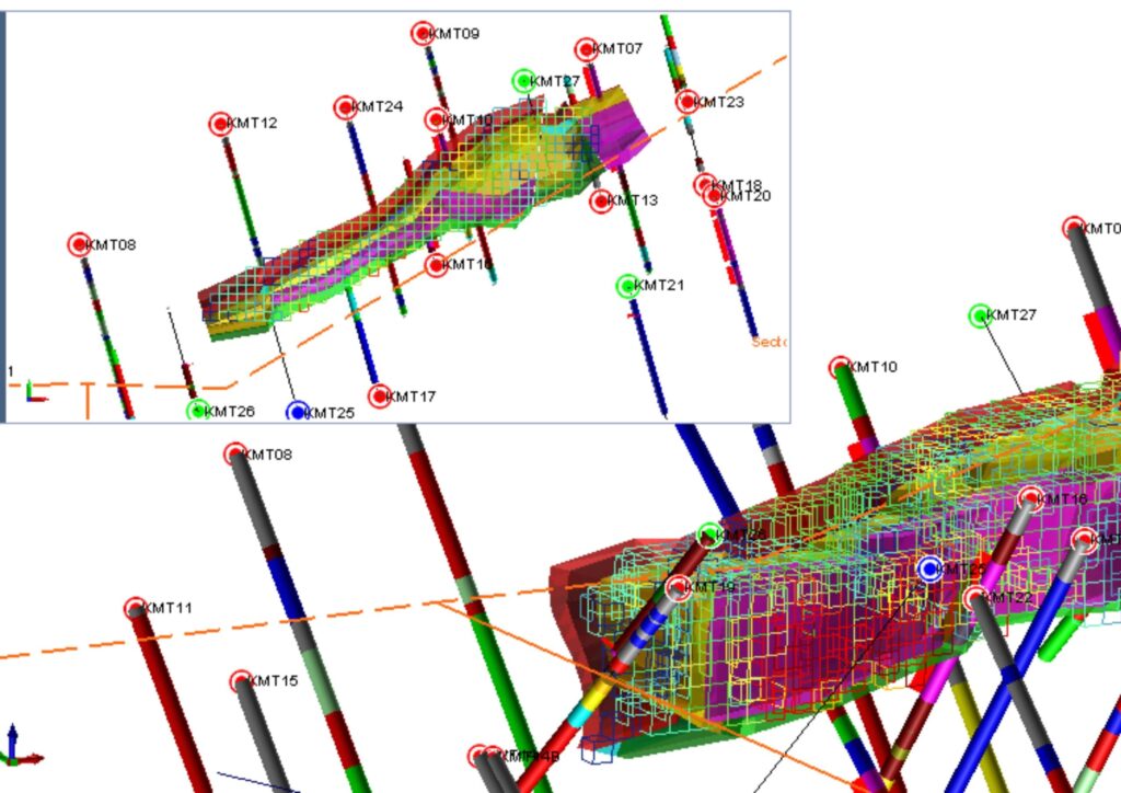
Wireframing
- Creates 3D geological models defining orebody structure
- Outlines mineralised zones based on geological and assay data
- Supports mine planning and block model development
- Provides a visual framework for resource estimation
Implicit Models
- Generate rapid 3D geological interpretations from drill hole data
- Use mathematical algorithms to model complex structures
- Reduce reliance on manual interpretations, increasing accuracy
- Improve decision-making for exploration and mining strategies
Semi-Automated Explicit Models
- Combine manual and automated modelling for efficient 3D geological interpretations
- Increase accuracy and consistency in orebody modelling
- Allow geologists to refine models based on real-time exploration data
- Improve resource estimation and mine planning decisions
Geometallurgical Models
- Integrate geological and metallurgical data to predict ore processing behaviour
- Enhance mineral recovery and processing efficiency based on ore characteristics and geospatial relationships
- Support cost-effective mine planning by optimising resource utilisation
- Reduce processing risks by identifying ore variability early
GIS SERVICES
Geographic information systems (GIS) involve the analysis of all spatial data, enabling the identification of patterns and trends.
Georeferencing
- Assigns geographic coordinates to digital images
- Enables accurate positioning on Earth’s surface
- Facilitates integration with other geographic data
Digitisation/Vectorisation
- Conversion of georeferenced images into vector data (points, lines, polygons)
- Trace desired features for digital utilisation
- Transition from hard copy to digital formats
Digital Maps/Plans
- Development of virtual representations incorporating desired data
- Provision of accurate depictions of areas
- Highlight important features visually
Terrain Analysis
- Used to interpret and analyse topographic features (slope, aspect, elevation, contours)
- Used for hydrological mapping, land component mapping, and elevation mapping
- Assess accessibility and identify potential target areas
Regional & Structural Trend Mapping
- Identification of geological trends and structural frameworks
- Used to understand crustal movements shaping current terrain
- Support the interpretation of local structures
Photogrammetry & Orthomosaic Processing
- Creation of 3D models from a series of photographs
- Generation of rectified overhead imagery at uniform scales
- Utilise drones for high-resolution 2D and 3D mapping
Drone Data DTM/DEM Processing
- Generation of Digital Terrain Models (DTMs) and Digital Elevation Models (DEMs) from drone data
- Used to calculate volumes, surface areas, and measure changes
- Effective spatial data analysis
Remote Sensing
- Remote detection and monitoring of physical characteristics of areas
- Use of satellite or aircraft imagery to measure reflected and emitted radiation
- Used to identify mineral target areas over large regions
- Exploration costs significantly reduced